Si esta es tu primera visita, asegúrate de echarle un vistazo a la AYUDA haciendo click en el enlace. Es posible que tengas que registrarte antes de nada. Haz click en la palabra "registrate" para iniciar el proceso de registro. Para empezar a leer mensajes, selecciona el foro que quieres leer de la lista de abajo.
Lee todas las normas del foro antes de publicar cualquier mensaje, estas han sido creadas pretendiendo ir en concordancia con el sentido común, el orden y la cordialidad. Cualquier miembro del foro ACEPTA todas las condiciones del mismo antes de publicar. En caso de incumplir alguna de las normas aquí expuestas, los moderadores o el Administrador podrán borrar, editar o cerrar el mensaje en cuestión sin previo aviso. Si necesitas que el Administrador o los moderadores te resuelvan alguna duda ponte en contacto con ellos haciéndoles llegar un mensaje privado.
Los moderadores están para cuidar del cumplimiento de las normas del foro. Realizan este trabajo sin ningún tipo de compensación para el bien de todos. Tenedlo en cuenta.
El Administrador se reserva el derecho de modificar, suprimir o ampliar estas normas si lo ve conveniente, previa publicación de las mismas.
Aún cuando el Administrador y moderadores de este foro harán todo lo posible por mover cualquier material cuestionable tan pronto como sea posible, es imposible revisar todos los mensajes. Por lo tanto tu aceptas que todos los mensajes por ti publicados en este foro, expresan tus opiniones y no la del Administrador, moderadores o webmaster (excepto en mensajes publicados por ellos mismos) por lo cual no se les considerara responsables.
Normas de comportamiento y de carácter legal
1.- Presta atención a las buenas maneras en el foro, este fue creado para intercambiar opiniones y experiencias, recuerda que detrás de cada Nick hay una persona con la que estás dialogando. Los insultos, tanto directos como indirectos, a cualquier miembro del foro (ya sea usuario, Administrador o moderador) no serán tolerados. Se pide con ello respeto y educación, tanto en el trato como en las formas hacia todos los usuarios. Se editara o borrara el hilo donde esto no sea cumplido y, se pedirá a los implicados que solucionen sus diferencias por privado. En caso que se estimen, por la gravedad e insistencia, el administrador podrá bannear al usuario.
2.- Se evitará cualquier manifestación, mediante texto, hipervínculos o imágenes, que atenten contra las leyes vigentes o, incite directa o indirectamente, a la promoción de actividades ilegales.
3.- No está permitido realizar SPAM en el foro, salvo si el Administrador o los moderadores lo consideran de especial interés/actualidad.
4.- Los moderadores, están aquí para mantener el correcto funcionamiento del foro. Si un mensaje tuyo o de otro usuario es borrado, editado, movido o cerrado no abras otro, tampoco para pedir explicaciones. Se borrarán automáticamente los mensajes o hilos abiertos por este motivo. No se moderan mensajes sin ninguna razón, la explicación está en estas normas. No se permitirá el cuestionamiento público de estas normas. Si alguien tiene algún problema o sugerencia al respecto, se enviará un Mensaje Privado a un moderador o un correo electrónico al Administrador. Con gusto les responderán con los motivos del borrado, edición, traslado o cierre del mensaje. No contestarán a dudas de este tipo por otro medio que no sea ese.
5.- Por favor, utiliza los MP (Mensajes Privados) para temas personales. Evita mensajes del tipo “Para xxxx”. Recuerda que un mensaje privado es PRIVADO, y no puede ser expuesto en público sin el consentimiento del autor del mismo.
6.- En caso de incumplimiento reiterado de las normas se procederá a un baneo y pérdida de nick al usuario en cuestión. Todo mensaje queda registrado con tu IP y cada persona es responsable de sus palabras. Esto no obsta a la edición o borrado de los mensajes que no cumplan las normas descritas en esta página
7.- Para evitar agravios comparativos con las empresas colaboradoras, queda prohibido hacer publicidad de ningún tipo (Autocaravanas, piezas, talleres, recambios, servicios...) con fines lucrativos, sea nuestro o no dicho negocio, incluido en el nombre de usuario y en la firma (incluya hipervínculo o no). De esta manera los que soportan la colaboración mediante banners publicitarios no tienen competencia desleal.
8.- Está prohibida la doble personalidad, una persona solo podrá usar un nick para participar en este foro. Los nick dobles serán suspendidos sin necesidad de previo aviso. El usuario que tenga más de un nick será sancionado en consecuencia y/o expulsado temporal o permanentemente.
Normas de educación y cortesía
1.- Trata a los demás como te gustaría ser tratado. Participa siempre con educación. Las faltas de respeto repetidas pueden ser causa de expulsión del foro
2.- Piensa antes de escribir y evita frases que puedan resultar ofensivas desde los puntos de vista de religión, raza, política u orientación sexual. Recuerda que internet es global y diferentes culturas tienen diferentes costumbres.
3.- Procura dar tus opiniones con moderación. La firmeza que muestres en darlas no debe implicar un desprecio hacia los demás. Evita los enfrentamientos personales, siempre hay una forma de expresar tu criterio sin molestar a los que puedan tener otra opinión. Ayuda a que no se perpetúen guerras de mensajes incendiarios y recuerda que los insultos o ataques personales están prohibidos. Tampoco está permitido participar en discusiones simulando la opinión de personas distintas (astroturfing) ni abusar del sistema llenando de respuestas los temas tratados acaparando la conversación.
4.- Ten en cuenta que en el lenguaje escrito es difícil dar entonación. Los emoticonos están para ayudar a transmitir tu estado de ánimo o entonación.
5.- Ten paciencia, sobre todo con los principiantes y los que comenten algún error, tarde o temprano te puede pasar a ti. Las actitudes recriminadoras suelen ser mal recibidas. Siempre se acepta mejor y se hace más caso a una respuesta expresada correctamente y en tono moderado.
6.- Contra las ofensas o los intentos de provocación la medida más efectiva es la indiferencia.
7.- En este foro se respeta tu intimidad por lo que se te pide que respetes la intimidad de los demás no dando, en ningún caso, datos personales de nadie.
8.- Se respetuoso. Si reproduces información de esta u otras webs, cita la fuente de donde la has sacado y pon el enlace de la misma. No se permitirá cortar y pegar textos, este tipo de aportaciones serán eliminadas automáticamente.
Consejos y normas de publicación de mensajes
1.- Ac Pasión es un foro de ámbito nacional, y por ello el lenguaje usado en el mismo es el castellano.
2.- Antes de realizar una consulta o plantear tus dudas, revisa los temas del foro o bien utiliza la búsqueda, ya que es posible que encuentres la respuesta que buscas en algún otro mensaje publicado con anterioridad.
3.- Antes de publicar tu mensaje, elije el subforo más adecuado para el tema que deseas colgar. Si no está en el subforo que le corresponde será trasladado sin necesidad de aviso.
4.- Los títulos de los mensajes deben ser explicativos del contenido, no importa si son largos. Esto da velocidad al foro pues los foreros ya entran donde saben que les interesa y también ayuda mucho a la hora de hacer búsquedas. Por ejemplo, titular un mensaje "Una duda", "Algo falla", "SOCORRO! problemas!", "Me aconsejáis",.... no es nada explicativo y tiende a hacer perder el tiempo a los foreros. Títulos correctos serian, " Oigo un zumbido en la parte delantera al girar a derechas", "Se me funde repetidamente el mismo fusible", etc... , largos y explicativos.
5.- Solamente están permitidos mensajes de compra-venta o cambio en el foro correspondiente. Se borrará cualquier otro mensaje o enlace, incluidas las firmas que no cumplan esta norma.
6.- No cambies de tema en medio de un hilo. Intenta buscar un hilo similar o, en su defecto, abre un mensaje nuevo. Intentemos evitar contestaciones del tipo "hombre, forero X, aprovechando que te encuentro żme podrías comentar como hiciste X cosa?"
7.- Si has realizado una pregunta y no has recibido respuesta, pregúntate si la has hecho de forma correcta o en el subforo indicado. Ten en cuenta que los usuarios del foro son voluntarios y que, por ejemplo, muchas veces no te responderán si la solución de su problema es fácilmente localizable usando el buscador.
8.- Escribe con corrección tus mensajes respetando la ortografía y la gramática, en la medida de lo posible. Recuerda que esto es un foro, no un teléfono móvil, tienes todo el espacio que necesites para escribir, no es correcto ni necesario escribir como lo harías en un sms. Tampoco es correcto escribir todo tu mensaje en mayúsculas, en internet se considera gritar, ni usar palabras malsonantes, groseras o hirientes.
9.- Esta prohibido abrir un tema del estilo "La tienda XXX son unos estafadores", o reflotar uno ya existente con ese fin. Siempre se podrá opinar de las experiencias de cada uno en las diferentes tiendas, talleres, etc..., pero con respeto. Estos problemas habrá que solucionarlos con la propia tienda, taller, etc..., y solo en caso de que la estafa quede demostrada judicialmente se podría llegar a permitir este tipo de temas.
10.- Para evitar discusiones, no se permitirán mensajes de religión y/o política, a no ser que guarde una estrecha relación con el autocaravanismo.
Normativa para Firmas y Avatares
1.- Las firmas podrán tener un máximo de 250 caracteres y podrán contener caritas "smiles"
2.- Las firmas no podrán contener imágenes externas a acpasion.com, para insertar una imagen personalizada como firma la deberemos subir directamente desde nuestro ordenador al foro, sin utilizar páginas de almacenaje de imágenes o utilizando enlaces directos a imágenes de otros lugares.
3.- Las firmas podrán contener un máximo de una imagen y estará limitada a un tamańo máximo de 450px (ancho) por 100px (alto) y con un peso máximo 120KB.
4.- Las imágenes para los Avatares deberán tener un tamańo máximo de 110px (ancho) por 110px (alto) y con un peso máximo 50KB.
5.- Está permitido incluir en las firmas, enlaces hacia blogs y paginas personales, pero queda prohibido incluir enlaces a webs y foros de esta misma índole. La publicidad de cualquier producto o negocio tanto propio como ajeno esta totalmente prohibida.
6.- No está permitido utilizar un logotipo o marca comercial como avatar o imagen de perfil.
7.- Cualquier avatar o firma que sea ofensivo/a o insultante hacia AC Pasión o para cualquiera de sus miembros, colaboradores o administradores será retirado/a inmediatamente.
8.- AC Pasión se reserva el derecho de solicitar la modificación, o modificar el avatar o firma de un usuario cuando éste no se cińa a las normas aquí establecidas.
Sobre baneos e infracciones
A partir de hoy día 24/07/08, los baneos o infracciones no serán obligatoriamente avisados con anterioridad por mensaje privado o email, a fin de evitar interpretaciones de tipo “me estáis amenazando, etc...”.
Si el administrador o un moderador ven un post ilegal lo borrará e, inmediatamente después, procederá al baneo del usuario que escribió dicho mensaje.
Si un usuario baneado hace uso del foro a través de otro usuario el mismo será expulsado del foro.
Ponemos un email a disposición de los usuarios baneados que deseen conocer la razón por la cual han sido baneados y, dependiendo de esta y los argumentos que se expongan, se procederá o no al levantamiento de dicho baneo.
El usuario puede solicitar la baja como usuario del foro en cualquier momento remitiendo un email a la dirección: [email protected], si bien el usuario debe conocer que el hecho de tramitación y solicitud de baja como usuario no implica retroactividad y no podrá exigir el borrado de mensajes y/o opiniones vertidas por el mismo en el foro ya que las mismas se mantendrán en el no pudiendo exigir su eliminación con acuerdo a las normas ya establecidas en este foro. Ya que son considerados mensajes y/u opiniones en un medio público y gratuito es decir, una aportación pública, en este caso a un colectivo y en un marco de colaboración, aportando información y detalles. La eliminación de los mismos privaría a todo el colectivo del acceso a esa información.
EL DESCONOCIMIENTO DE LAS NORMAS POR PARTE DE LOS USUARIOS NO EXIME DE SU CUMPLIMIENTO Y MUCHO MENOS LES DA DERECHO A QUE EL ADMINISTRADOR O LOS MODERADORES TENGAN QUE JUSTIFICAR SUS ACTOS EN CUMPLIMIENTO DE DICHAS NORMAS.
El Danubio es un vínculo natural con el vecino, no sólo Rumania, sino también con los demás países a lo largo del río.
La región alberga la única reserva de la biosfera de Chuprene, el magnífico Belogradchik rocas, las formaciones rocosas en Borov kamak y Chuturite, lotes de cuevas (Magura, Venetsa).
La principal vía férrea en la región es la Sofía - Mezdra - Vratsa - Vidin. Los dos puertos (cerca de Vidin y cerca de Novo Selo) y el ferry de ferrocarril de automóviles sirven como un atajo entre Europa Occidental, Bulgaria y el Mar Egeo.
La historia cultural se refleja en los numerosos monumentos arqueológicos, fragmentos arquitectónicos, esculturas, de bronce y arcilla, elementos que se conservan en los museos.
Los antiguos asentamientos de Ratsiaria (hoy Archar) y Bononia (actual Vidin) y Castra Madres fortaleza (hoy Kula) son pruebas de los progresos realizados por los asentamientos durante la época romana.
Durante dos milenios la región ha sido un importante centro militar, el transporte y el centro comercial, lo demuestran las numerosas las obras de defensa construidas en la vecindad.
La ciudad de Vidin se encuentra al noroeste de Bulgaria, a 199 km de Sofía, en la orilla derecha del río Dunabe. Está conectada con la ciudad de Kalafat (Rumania) por un transbordador.Un importante factor de la ciudad es su recurso de la disponibilidad de agua mineral.
Vidin es una de las ciudades más antiguas a lo largo del banco búlgaro del Danubio.Aparece como la fortaleza romana de Bononia sobre los cimientos de una solución de Tracia.
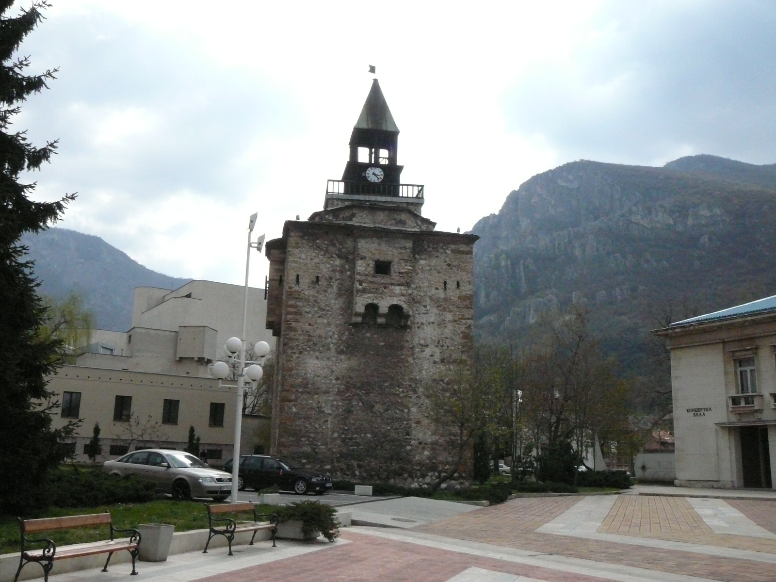
Durante el segundo reino búlgaro es un gran fortaleza y un después de 1371 la capital de Espańa en virtud de Vidin Zar Iván Sratsimir.
Hasta el día de hoy los siguientes sitios se han conservado: Fortaleza de Baba Vida, construida en el siglo IX-X sobre las ruinas de una fortaleza romana (reconstruido muchas veces, su aspecto actual se remonta al siglo XVIII), el turco Konak (segunda mitad del siglo XVIII), la mezquita y la biblioteca de Osman Nuri Pasha, el cuartel de la cruz 1798, antiguos edificios del Renacimiento, una sinagoga.
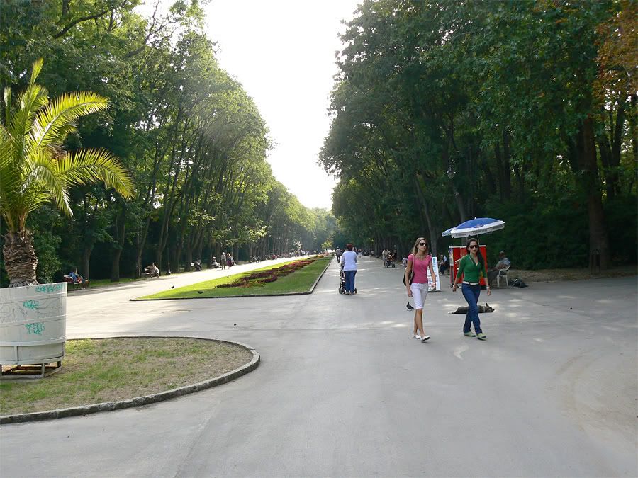
Vidin es un punto de partida para excursiones a lo largo del Danubio.
El segundo puente sobre el Danubio entre Bulgaria y Rumanía se construirá allí.
The town of Rousse (162 128 inhabitants, 50 metres above sea level) is located on the high right bank of the Danube River, 496 m from the outflow of the big river. It is 320 km north-east of Sofia, 203 km north-west of Varna, 106 km north-east of Veliko Turnovo, 146 km north-east of Pleven, 97 km north-east of Svishtov, 122 km south-west of Silistra, 66 km north-west of Razgrad. The greatest and the most important Bulgarian town on the Danube River, known also as “Little Vienna” because of its ancient architecture. It is a regional administrative centre. View Rousse Photo Gallery The Rousse-Giurgiu Friendship Bridge
Danube River Cruises The mighty Danube River, named by the Greek historian Herodotus "The King of the European Rivers," forms much of Romania's southern border. The Danube enters the territory of Romania at the famous Iron Gates (Portile de Fier) and ends its 670 mile journey through the country in the Black Sea. Before meeting the Black Sea, the Danube forms one of the most spectacular wetlands in the world, The Danube Delta - a unique 2,100-square-mile wildlife reserve - home to more than 300 species of birds and about 160 kinds of fish, both fresh and salt-water species. Sights along the Danube
Among the many sights near or along the Romanian section of the Danube River, worth visiting are: the ruins of the Roman bridge at Drobeta,
Topolnita Cave,
The Iron Gates Dam,
the cities of Drobeta Turnu Severin,
Orsova, Giurgiu, Oltenita,
Braila,
Galati and Tulcea.
Bucharest, Romania's capital city, is only 40 miles north of the cities of Giurgiu (Romania) and Ruse (Bulgaria), both situated on the banks of the Danube. Cruise companies
Companies offering cruises on the Danube River, from Germany or Austria, to Romania include: Value World Tours Vantage Deluxe World Travel Uniworld Scylla Tours Sailing with privately owned boats
Sailing on the Danube, with privately owned boats, is allowed for the entire Romanian section of the river.
The only formalities required when sailing from Vienna, Budapest or Belgrade are:
- passport check,
- yacht/ boat technical inspection.
No inoculations are required, no visa for Americans, Canadians and citizens of the Europe Union countries. There are two Danube Border Checking Points :
Orsova and Drobeta Turnu Severin (or Turnu Severin for short)
Required documentation:
- passport
- yacht / boat proof of ownership & registration
There is a yacht/ boat fee of $15.00 to $30.00 depending of the size of the boat.
For further information please contact:
Orsova Danube River Authority
(011 4) 0252 361.295
Drobeta Turnu Severin Danube River Authority
(011 4) 0252 316.493 A cruise on the Danube
This section is courtesy of Mrs. Bernice S. Kopelman / BSK, Travel Correspondent
E-Mail: [email protected] Best of the Balkans
Notes & Observations from Budapest to Bucharest
My idyllic mid-summer's riverboat cruise down the Danube, terminating at the Black Sea aboard the sparkling new Uniworld "River Countess" was a leisurely way to take in this part of Europe.
After a 12-year hiatus, Uniworld returns to its "routes" with a Hungary to Romania itinerary along the Danube. Interspersed with quaint towns and villages, this turbulent part of Eastern Europe is out from under the Communist grip as recently as the last decade. Millions of Americans can claim origin to this region of Europe.
From the outset, I expected our Budapest stopover to be brief (necessitated by the itinerary) but also somewhat rewarding.
As it turned out, the early afternoon arrival and the 30-minute drive from the airport to Pest where the Countess was docked was without fan-fare. Riverboats have the distinct advantage of tie-ing up in the heart of each city/village. So....tout-de-suite, I was out on the "Vaci Utca", a pedestrian only promenade leading to "Vorosmarty Square" and my intended destination the famous Salon de the Gerbeaud, a 19th century patisserie/rathskellar, always featured in articles extolling Budapest. It was well worth the stop to savor the excellent homemade ice cream, hand whipped crčme topping and solo made waffle cones. The cost was minimal!
Back aboard the Countess all the cabins are virtually configured the same with excellent bedding, a sensational bathroom (especially considering its compactness), ample closet space (for 2 loaded with clothes), and adequate amenities. Uniworld prides itself on cleanliness and service, certainly their newest riverboats (4 in all) are worthy of 5 stars in all categories. The huge open-air top deck mimics the 3 below and features exemplary seating and the tranquility that one may look forward to on a riverboat cruise. Ports of Call (rundown): Day 1: leave the USA / your home-country
Day 2: arrive Budapest
Day 3: Kalocsa
Charming town of Kalocsa and a visit to the centre of Hungarian Paprika production (a multi-million dollar industry). Then onto a very popular and exciting horse show at a Hungarian ranch...passengers took it all in and gave it a "thumbs up"! Hungarian cowboys are still the main source of ranch & farm labor as mechanization has yet to come to eastern Europe. Back at dockside, a small shop with prepackaged paprika products and locally embroidered items (that's what they said) was inundated with cruisers purchasing well-priced gifts for family & friends. Day 4: On the Danube
Cstoms stops in Mohacs, Hungary and Bezdon, Serbia ...a welcome respite before a full day tour in Belgrade.
Very picturesque landscape along this wide stretch of the Danube prior to some very impressive locks. Day 5: Belgrade
Points of interest here (at the confluence of the Danube & Sava Rivers) were Tito's Memorial and Saint Sava Cathedral, largest Eastern Orthodox Church in the world. A guide in this city is a real asset since the Hungarian & Serbian languages are some of the most difficult in the world. Housing still remains the pre-cast concrete "boxes" of Communist days. Visit the Bohemian Section....the cobbled streets are lined with flower bedecked restaurants and entry into this area is gate-secured. This is where you can sample exceptional regional food. Prince Michaell Promenade is traffic-free and lined with so-so shops. Day 6: The Irongates & Vidin
Cruising through a picturesque region and exit the "Irongate", defined as a narrow Danube gorge between the Carpathian & Balkan Mountains, it forms a natural border between Serbia & Romania.
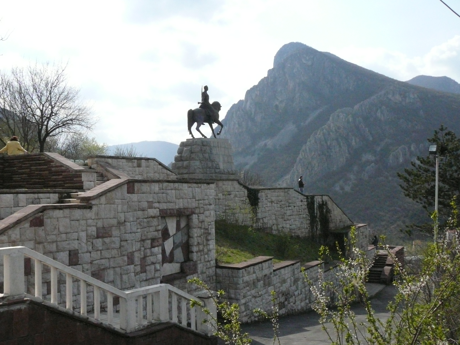
After lunch, arrival in the ancient Bulgarian town of Vidin and a tour of the Baba Vidin Fortress, an imposing presence that dominates the town & river. Day 7: Rousse-Veliko Tarnovo
Driving through tree-lined streets and a visit to the Pantheon, a contemporary mausoleum dedicated to the saviors of the region. The city was a natural fortress. We continue to the museum town of Arbanassi for a typical farm-house lunch...then a visit to Peter & Paul Monastery and shop for local handicrafts (not much) and back to Rousse for a walk-about, window-shopping, and return to our riverboat. Day 8: Constanta
Constanta is Romania's 2nd largest and oldest city, the last port of call (before disembarking for a bus ride to Bucharest).
Everyone's excited about visiting this cultural centre and setting their feet in the Black Sea. The city tour included the Opera House, Cathedral of Peter & Paul and the Great Mosque before stopping off at the Riva Hotel in the Mamaia Area....a world-renowned resort-getaway. Swedes, Norwegians and Germans frequent as guests ifrom May until September. The beach scene offers innumerable older hotels with newer ones in various stages of construction. Existing hotels have a guest capacity of about 75,000. Colorful facades are a pleasant surprise and a welcome response to the bland box-like housing of Communist vintage. The highlight of this day was a rare visit to Murfatlar, one of Romania's prestigious vineyards ... where we were graciously entertained with a folkloric extravaganza, an appetizer plate and a wine tasting of 4 assorted varieties all in a cavernous wine cellar on the estate. Wines are generally cheaper and plentiful in local stores. The evening ended with a dinner & a walk-about in the in the port of Constanta. Day 9:
Our final day of the cruise and a 3-hour drive through agricultural Romania. This was the season of apricots, peaches, cherries....with villagers selling assorted seasonal produce along our bus route. Our destination, the capital city of Bucharest a stunning revelation with broad boulevards, exquisite historic buildings and parks wherever you look.
The dilapidated housing (again of Communist vintage) has left its mark on the city's architecture. Despite this...... the Opera House, the Medical School, the Parliament Ceausescu's Palace
Staying in centre city at the Intercontinental Hotel is the perfect choice. It retains its 5-star quality with lovely rooms, many amenities and low & behold ...one of the many casinos which came to Bucharest back in 1991. Hours of operation vary with some taking US dollars while others only local currency. Imagine hitting on the slots with an exchange rate of 33,200 Romanian "Lei' to the US dollar.
Casinos generally offer complimentary food & beverage, and yes......I did try my luck!
Bucharest is a "walkers" delight so my extended walking tour to "check out" shopping venues and prices was most pleasurable. I exchanged $100 US & got 3,200,000 Lei....."what a trip"!
I was also surprised to find Bucharest replete with "theme" restaurants, i.e. Dracula! "Count Dracula Club", the most unique of the lot inspired by the novel "Dracula", wandered through its assorted rooms and enjoyed a menu that ties the theme together.... and as they say, "you must go"!
Although the trip was never intended to be "a return to one's roots", I did make inquiry about the "hick town" my father left as a teenager... Dorohoi in Moldova, a region northeast of Bucharest near the Ukraine border.....now more or less a thriving small town "metropolis" with a population of about 35,000.
Romania turned out to be the most exciting country on this riverboat odyssey. You can sense the vibes, hard work, acceptance of Americans and the desire to have Americans re-visit their country as was the case in the pre-Communist eraplus others to numerous to recall are all truly a feast for the eyes. was incredible......it is the 2nd largest building in the world and the construction of his "Champs Elysee" edifice consumed most of the country's gross national product for years. I visited the. Map of the Danube ))))))))))))))))))) Transport: Bus, railway and river transport services the inter-town and international connections of the town. There are regular bus lines to Sofia, Varna, Pleven, Veliko Turnovo, Shoumen, Razgrad, Turgovishte and a lot of other towns and villages of the country. There are two bus stations functioning in the town – Iztok (East) Bus Station (10, Ivan Vedar Street, tel.: 082 443836, 228151, 444810) and Yug (South) Bus Station (156, Alexander Stamboliiski Square, tel.: 082 222974, 228151, 228100). Rousse is the initial (or the final) station of two railway lines Rousse - Gorna Oryahovitsa Stara Zagora Podkova and Rousse - Kaspichan - Varna. It is connected through them to the national railway network. There are two railway stations in the town - one in the eastern part and the Central Railway Station (in the western part, tel.: 082 222213, 224320). There is a town railway ticket bureau (082 222845) and an office for sleeping car reservations (082 224202).
The river station of Rousse is a big one. Since 1992 the river passenger transport along the Bulgarian Danubian riverside have been discontinued but their continuance is solely a matter of time. There are cruises only along the international route Rousse - Belgrade - Novi Sad - Budapest - Bratislava - Vienna - Linz - Pasau with Bulgarian and mainly foreign tourists. Tourist’s tour cruises on little ships are organised during the summer. Since 1993 the ferryboat line Rousse - Giurgiu has been in operation, too. There is town bus and trolley bus transport in Rousse.
Tourist information: at the hotels and at the tourist chalets. At Prista Tourist Association (1, Knyazheska Street, tel.: 082 224705, 225454) and at Akademik Tourist Association (8, Studentska Street, tel.: 082 450887). Accommodation: The Riga Hotel Square (Svoboda Square). The Danube Hotel (Svoboda Square). The Splendid Hotel. The Yordan Petrov Hotel (Prista Western Park, on the bank of the Danube River opposite the island of Lyulyaka (Lilac), working hours: 8:00 a.m. - 11:00 p.m., there is a restaurant). The Dom na Armiyata (House of the Army) Hotel (2, Odrin Street). The Rai (Paradise) Motel. The Prista Chalet (in the western park of the same name, offering 132 beds in 3 suites and in 2-, 4-, 5- and 7-bed rooms, there is a town bus line to it). Lyulyaka Camping (in the PristaWestern Park, on the bank of the Danube River opposite the island of the same name, it has 24 beds in double rooms two rooms in a bungalow. . The Danubian Carnival is a masquerade held around 24 June,Enyovden.
Citizens of Rousse seem to be generally fond of celebrations. There is the city summer festival with events taking place each Thursday from May to October, the Danube Carnival, held on June 24 to honour the summer solstice and mark the beginning of the winter season, and the Shrove Sunday noisy masquerade pageant. Such cheerful processions might be typical for Greece or Brazil, but are not common in Bulgaria, which gives Rousse a unique scene. Today things are looking up for Rousse. Significant investment is flowing into the town, the industrial zone is coming to life, and the town's architectural beauty has withstood the test of time. The central part of the city arrests tourists’ attention with its unique 19th and 20th century Neo-Baroque and Neo-Rococo architecture. The influence of the Viennese school may be seen in many of the houses. Among the paragons of architectural ingenuity one can find churches, museums, monuments, libraries and others, but a building called “Dohodnoto” (or the Profit-Yielding Building) on the Central Square, stands out. It was built in 1902 by the architects Raul-Paul Branck Georg Lang, Franz Schotlz and construction expert Petar Atanasov. A sculpture of Mercury, the winged god of commerce, graces the facade, because the building was originally designed as a trade centre. It was intended to provide the school board of trustees with funds by renting the theatre hall, library, casino and shops. Downtown Rousse is people-watchers’ heaven with many cafes lining the pedestrian-friendly Alexandrovska Street. From any outdoor cafe you can watch the town come alive, though if you normally greet the mornings in an urban centre, you may feel that Rousse never quite wakes up. Few people stride here, most stroll.
)))))))))))))))))))))))))))))))))))))))))))))))))) ))
Landmarks: About 200 buildings in Rousse are considered part of architectural historical heritage of Bulgaria, 12 of which are especially valuable. In the first place this is the Dohodnoto Zdanie (The Profitable Building) with the winged Mercury on its roof (the Old Theatre), built in 1902 by the architects Raul Brank, Georg Lang and Frank Scholts, which together with the Monument to Freedom (1908), a remarkable work of the architect and sculptor from Florence Arnoldo Zocci, are the symbols of Rousse. The following are also among the most outstanding cultural and historical monuments: The High School of Music; the Catholic Church (Episkop Bossilkov Street, tel.: 082 228188) with coloured stained-glass; the buildings of the Savings Bank, the Chamber of Commerce and Industry (Lyuben Karavelov Library), the boys’ high school “Knyaz Boris” (now a secondary vocational school “Hristo Botev”); The house of the sailor; the Regional Administration (granted for a museum); The Club of the Culture Functionaries; The Duty-Free Zone Administration; the Simeonovs Brothers’ House. The native home of Elias Kaneti is located at 13, Gurko Street.
Rousse is a town of the museums: The Pantheon of the National Revival Heroes (tel.: 082 28913); The Town Museum of History; the Baba Tonka Museum (phone: 082 32364); the Zakhari Stoyanov House-Museum; Toma Kurdzhiev House-Museum; The Museum of the Town Lifestyle arranged in Kaliopa’s House (tel.: 082 27742). The National Museum of Transport and Communications is housed in the building of the oldest railway station of Bulgaria. Carriages of Sultan Abdul Aziz, of Tsar Ferdinand and Tsar Boris III are preserved in it. The Town Art Gallery.
The ancient sites of interest of the town also include Leventabia Fortress (a restaurant complex now), the Kyuntukapiya Gate from Mitiriza, the Mahmoud Column, the Holy Trinity Church (8, Holy Trinity Square) dating back to the beginning of the 17th century, the Fleet Tower, built in 1884 by architect Franz Gruenanger for meteorological observations. There are monuments to those killed in the Serbian-Bulgarian War of 1885, to Russophilles, to Baba Tonka, to Lyuben Karavelov, Stefan Karadzha, Raycho Nikolov, etc.
There is an Opera House in Rousse (Sveta Troitsa Square, tel.: 082 234303, 225358), a Philharmonic Orchestra (12, Rayko Daskalov Street, tel.: 082 225680), Theatre of Drama and a Puppet Theatre. The International Festival “March Days of Music” is annually held in the town.
There is a higher educational institution, too the University of Rousse.
History: The famous Rousse mound - a prehistoric settlement existed more than 5000 years ago is located within the boundaries of the modern town. At the beginning of the new era on a part of the territory of the modern town of Rousse an ancient settlement of Sexaginta Prista (The sixty ships) emerged, where “prista” means a particular type of a Greek river guard vessel. Probably it was founded by the Roman Emperor Vespasian (69-79). Later on it was known under the names of Pristis and Pristapolis. It existed up to the 6th century, when the Avars brought it to ruins. In Medieval times a new settlement emerged near the ruins of the ancient settlement, and information about it was found for the first time in the Broush Guidebook of the 16th century under the name of Rossi. In the Sultan Register of 1431 and in a Peace Treaty concluded between the Ottoman Empire and the Magyar state dated 20th of August 1503 the settlement was mentioned under the name of Roussi. In Ahmed Neshri chronicles as well as in many other old maps the town was shown as a wholesome town together with the settlement of Giurgiu on the opposite side of the Danube River named Yorgogi, Yorgovo, Yuroukova, Roussi on both sides of the Danube River, Giurgiu on both sides of the Danube River.
In 1595 the Wallachian ruler Mihai Vityazoul (the Courageous) made an attempt to liberate Bulgaria with an Wallah-Bulgarian army and the town was brought to ruins. After its reconstruction at the beginning of the 17th century it was given the name of Rouschouk (little Roussi). The town turned into an important port and a strong border fortress. In 1811 the Russian General Koutouzov carried out the famous Rouschouk battle and became known as a talented military commander. In 1864 the town became the centre of the Danube District of the Ottoman Empire. In 1866 the building of the first railway road in Bulgarian lands - Rouschouk-Varna was completed. The first modern agricultural farm was founded under the name of Noumine (Exemplary farm). The River Management was founded as well and in a short period of time 7 steam ships and 15 barges were purchased. A printing house was opened with printing machines from Vienna where newspapers, books and textbooks were printed. The bookshop of Hristo G. Danov was opened at that time. To meet the needs of the secular education in Rouschouk in 1843 Alexander Rousset published in Strasbourg the first geographical map in Bulgarian.
European influence penetrated into the town through the active river transport along the Danube River (predominantly Austro-Hungarian ships) and this had positive impact on the development of the town. Architecture developed, too and the construction of private and public buildings resembling the style of the capital of the Austro-Hungarian Empire Vienna commenced. The European fashion in clothing also penetrated first in this Bulgarian town.
On the 1st January 1866 the first in Bulgaria meteorological observations began here with modern Austrian equipment.
Rouschouk was not left aside from the struggle for spiritual and national liberation either, moreover that in its capacity of being a gate to Europe it was here that the modern freedom-loving ideas of the Old Continent made their way into the country. Zora (Dawn) Chitalishte (reading room and community centre) and the home of the extraordinary Bulgarian woman patriot baba (grandmother) Tonka Obretenova became centres of the national struggle. A lot of revolutionaries were assisted to leave the Empire or to return to their Fatherland. It was here that Angel Kunchev - one of the most faithful and ardent followers of Vassil Levski died here during an exchange of fire with the Turkish police. Baba Tonka, her sons and daughters, revolutionaries who gave their lives for the freedom of Bulgaria - Stefan Karadzha, Angel Kunchev, Zahari Stoyanov, Lyuben Karavelov, Panayot Hitov, Hristo Makedonski, Dimitur Tsenovich and a lot of other great Bulgarians were buried in this town.
A Pantheon-Charnel House of the national Revival heroes with an everlasting fire was opened in Rousse in 1979. The bones of many of the 453 dignified Bulgarians, who were born in or who linked their lives with this town and whose names are inscribed in the Pantheon were collected in it. On 20th February 1878 the Russian Army led by General Totleben entered Rouschouk and was enthusiastically welcomed by the population led by Archbishop Kliment Branitski (Vassil Droumev).
The town was the biggest in the liberated Bulgarian lands over 20 000 inhabitants. On 31st July 1879 the Bulgarian flag of the ships donated by Russia was risen which marked the beginning of the organised Bulgarian river navigation. The first marine technical school, later on moved to Varna, was opened here in 1881. The same year was found the first Bulgarian bank Girdap. In 1889 the first Bulgarian Chamber of Commerce, and two years later the first joint-stock insurance company –Bulgaria - were established in Rousse. As of the end of the 19th century a lot of celebrated architects did their creative work in the liberated of Rousse (Edward Winter, Udo Ribau, Georg Lang, Edwin Petritski, Negos Bedrossyan, Todor Tonev, Nikola Lazarov and others), painter-decorators (Karlo Francescani, Giovanni Pitor and others), landscapers (Ferdinand Halober, Rihard Noyvirt and others). It is not due to randomness that Rousse is being considered the most European Bulgarian town even nowadays. The writers Elias Kaneti, awarded the Nobel Prize for literature for 1981, Dobri Nemirov, Michael Arlan were born here, Lyuben Karavelov, Ivan Vazov, Stoyan Mihailovski, the poet Tsvetan Radoslavov, author of the text of the Bulgarian national anthem, the painter Joul Pasken (Pinkas), the pianist Otto Liebih, the opera singer Mimi Balkanska, Academician Mihail Arnaoudov lived here.
The role of the town grew up even more with the construction of the so-called Bridge of Friendship between the Bulgarian and the Rumanian banks in 1954. It was here that at the end of the 1980-ies the civil movement for protection of the town from the pollution of the Giurgiu Chemical Works (Rumania) originated and it marked the beginning of the democratic changes in Bulgaria. Nowadays Rousse is a big economic, transport, cultural and tourist centre.
Vratsa (transliterado también como Vraca or Vratza, en algunas lenguas, con W; Búlgaro: Враца) es una ciudad situada en el noroeste de Bulgaria, en una zona de colinas en los Montes Balcanes.
Es la capital administrativa de la pronvincia deVratsa -Vratsa Province. La ciudad de Vratsa es un centro de comercio y artesanía, y un nudo ferroviario, y en ella se ha establecido la industria textil, metalúrgica, química y cerámica. Durante el dominio otomano (Siglos XV al XIX, fue un centro administrativo y una guarnición. El área municipal está habitada por un total de 80.040 personas, según el censo de 2004.
Geografía Es una de las ciudades más "pintorescas" del páis. Se encuentra en las colinas situadas a los pies de "Vrachanski Balkan" (Montańas Vratsa), con el río Levakm de la capital búlgara, Sofía.
El área rural del municipio ofrece diversos atractivos, que le otorga el encanto de la zona oriental del noroeste búlgaro. En los terrenos de bosques del estado de Vratsa, se localizan numerosos parques naturales protegidos, así como monumentos históricos. cruzando la ciudad. Vratsa se encuentra a aproximadamente 116
Historia
El origen de la ciudad se remonta a los antiguos Tracios. Vratsa fue llamada Valve("puerta de la fortaleza") por los romanos, debido al estrecho paso que conducía a la puerta principal de la ciudad. Aun hoy, este paso es el símbolo de Vratsa, y está presente en el escudo de armas de la ciudad.
Tras la caída de Roma, Vratsa pasa a manos el Imperio de Oriente, Bizancio. En el siglo VI, la ciudad es habitada principalmente por tribus eslavas del sur, provenientes de Pannoia y Dacia, aunque continuo bajo el dominio de Bizancio.
En el siglo VII, Búlgaros y eslavos forman el estado de Bulgaria del que la Vratsa esalva forma parte. El municipio crece, y se convierte en un punto estratégico dada su proximidad con la frontera sur. El nombre de la ciudad cambia de Valve al eslavo Vratitsa, que tiene el mismo significado y del cual deriva el nombre actual. Vratsa toma fama por su producción y comercio de piezas de plata y orfebrería y cerámica de gran calidad, así como por su importancia estratégica.
En el siglo VIII, el ejército Búlgaro toma Sofía, lo que supone un descenso de la importancia de Vratsa, en detrimento de la mejor posicionada Sofía, que cuenta además con una economía más desarrollada y una mayor población y extensión. Sin embargo, pronto la recupera, cuando se convierte en un centro de la resistencia contra los invasores bizantinos, serbios y Magiares durante la Edad Media.
Turismo Las cercanas montańas y bosques favorecen el turismo, al poder desarrollarse actividades como caza, pesca, espeleología,fotografía, así como ofrece buenas oportunidades para practicar actividades deportivas, montańismo, ciclismo, ala delta, vuelo en paramotor, o rutas y competiciones en Kart, Buggy o Motocross.
La ciudad también cuenta con museos, piscinas, discotecas y otro tipo de complejos de ocio, destinados al turismo familiar, y es punto de encuentro de los interesados en deportes de invierno.
Transportes La ciudad cuenta con lineas de autobús y ferrocarril para los desplazamientos a los pueblos de la región, así como lineas regulares a otras urbes búlgaras; Sofía, Pleven, Vidin, Montana, Kozloduy, Oryahovo, Mzdra. La estación de autobuses se encuentra en el camino entre el centro urbano y la estación de tren.
La estación de trenes, que se encuentra en el noreste de la ciudad, destaca por su importancia en la ruta ferroviaria Mezdra — Boychinovtsi — Brusartsi — Vidin (Lom).. La ciudad enlaza con la linea nacional de ferrocarriles a través de la estación de Mezdra.
Yambol (Bulgarian: Ямбол) is a city in southeastern Bulgaria, the administrative centre of Yambol Province. It lies on both banks of the Tundzha in the historical region of Thrace. Today, the town has 85,966 inhabitants as of 2006[update]. It is occasionally spelt 'Jambol'.
The surrounding area has been inhabited since the Neolithic and was the location of the Thracian royal city of Cabyle (later conquered by Philip II of Macedon and the Romans, but destroyed by the Avars in 583). What is today Yambol was founded by Roman EmperorDiocletian in A.D. 293; though it was named Diospolis ('city of Zeus'), the name also reflected the emperor's name.
.
The name later evolved through Diampolis, Hiambouli (in Byzantine chronicles), Dinibouli (Arabic chronicles), Dbilin (in Bulgarian inscriptions), and Diamboli to become Yambol. There is a trend today to reflect its original connections by calling it Yamboli, but that remains unofficial.
As the Slavs and Bulgars arrived in the Balkans in the Middle Ages, the fortress was contested by the Bulgarian Empire and the Byzantines until 1373, when it fell to the Ottomans after a prolonged siege.
Yambol (Ottoman TurkishYanbolu) was an important centre of the Ottoman Empire until liberated by Russian forces in January 1878 to become part of Eastern RumeliaUnification in 1886.
The predominant religion is Eastern Orthodoxy with a number of churches being present (among them one of the Holy Trinity, one of St George; the largest one is the cathedral of St Nicholas) consecrated in 1888; there also exist Eastern Rite CatholicProtestant religious buildings. It also has a recently renovated 15th-century mosque and sheltering the tomb of Ismail Hakim Pasha who is reputed of sparing the lives of the city's native Bulgarian population in the 1870s; after a Sultanic order to 'pass them all under the sword' he simply made them walk 'under a sword'). and later Bulgaria after the and
.
The city was affected by the turmoils of the early 20th century. Its Greek population (around 20 families) left during the exchange of populations between Bulgaria and Greece and it received in return Bulgarians from Greece. It also hosted Bulgarian Macedonian refugees from the failed 1903 Ilinden Uprising. During World War I, Yambol hosted a base for Luftstreitkräfte (Imperial German Army Air Service) zeppelins used for missions in Romania, Russia, Sudan and Malta.
The town was chosen by the Germans due to its favourable location and weather conditions.
In the early 21st century, the city became the first one in Bulgaria to use natural gas for domestic purposes. Yambol Peak on Livingston Island in the South Shetland Islands, Antarctica is named for Yambol.
Yambol Province Yambol is a town with province in south eastern Bulgaria, neighbouring Turkey to the south. Its main city is Yambol, while other towns include Straldzha, Bolyarovo and Elhovo. It has an area of 3336 km˛ and, according to the 2001 census, a population of 156,631. The current population is estimated at 141,157. Municipalities Yambol Province is divided into the following municipalities: Bolyarovo . Elhovo . Straldzha . Tundzha . Yambol
Estado de la Ciudad del Vaticano Coordenadas 41° 54′ 0″ N, 12° 27′ 0″ E
El Vaticano (nombre oficial, Estado de la Ciudad del Vaticano) es una ciudad-estadoenclavada en la ciudad de Roma en la Península Itálica. Es uno de los microestados europeos. Tiene una extensión de 0,439 km˛ y una población de aproximadamente 900 habitantes,[1] por lo que resulta el Estado soberano menos extenso y menos poblado del mundo, seguido de Mónaco, que cuadruplica su tamańo. Es tan pequeńo que sólo la Basílica de San Pedro es un 7% de su superficie; la BasílicaPlaza de San Pedro ocupan un 20% del territorio, esto lo convierte en el país más urbanizado del mundo. Su nombre viene del Monte Vaticano (del latín "vaticinĭum": predicción; antiguamente moraba la colina un oráculo etrusco). Fue creado en 1929Pactos de Letrán celebrados entre la Santa Sede y el entonces Reino de Italia. que está y la mediante los La denominación oficial completa en latín de este estado independiente es: STATVS CIVITATIS VATICANĆ (una aproximación hispanizada de la pronunciación en latínrestituta, «státus kiuitátis uaticánae»). En italiano la denominación completa es Stato della Cittŕ del Vaticano. eclesiástico es «státus chivitátis vaticáne»; según la pronunciación El Estado de la Ciudad del Vaticano alberga la Santa Sede, máxima institución de gobierno de la Iglesia Católica. Aunque los dos nombres «Ciudad del Vaticano» y «Santa Sede» se utilizan a menudo como si fueran equivalentes, el primero se refiere al estado independiente y a su territorio, mientras que el segundo se refiere a la institución que dirige la Iglesia y que tiene personalidad jurídica propia (como sujeto de Derecho internacional). En rigor, es la Santa Sede, y no el Estado vaticano, la que mantiene relaciones diplomáticas con los demás países del mundo. Por otro lado, el Vaticano es quien da el soporte temporal y soberano (sustrato territorial) para la actividad de la Santa Sede.
Ciudad del Vaticano se compone propiamente de la ciudad vaticana y de los terrenos de Castel Gandolfo, separados a 34km entre ellos. Castel Gandolfo es el lugar donde tienen tradicionalmente su residencia de verano los Papas. El territorio vaticano está rodeado completamente por la República de Italia. (Wikipedia)
ooooooooooooooooooooooooooooooooooooooo
Con una superficie de apenas 44 hectáreas, la Ciudad del Vaticano es el estado independiente más pequeńo del mundo, ya sea por el número de habitantes que por su territorio. Su frontera está delimitada por las murallas y, en la Plaza San Pedro, por la franja de travertino que une las dos alas de la columnata.
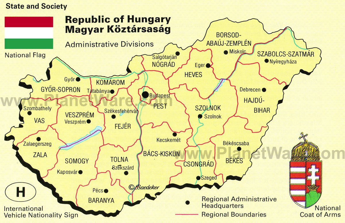
Si ama la naturaleza y la tranquilidad, amará Hungría. En pleno centro de Europa, el país está rodeado por Ucrania, Rumania, Serbia, Croacia, Eslovenia, Eslovaquia y Austria. ˇSólo eso!. Es el punto de partida ideal para visitar las maravillas de Europa Central.
El país no tiene acceso al mar pero está atravesado por el Danubio, el segundo río europeo en cuanto a longitud.
Hungría encierra además el lago Balaton, el lago de agua dulce más grande de Europa Central. Es también el principal lugar turístico del país. La ciudad de Keszthely se encuentra muy cerca de allí. Podrá visitar el castillo Festetics, que data del siglo XVIII. El castillo encierra varias obras de arte, así como una biblioteca de 50 000 libros. Sobre la ribera norte del lago, se halla el pueblo de Tihany. La casi-isla de Tihany es también el primer parque natural del país, y posee una estupenda iglesia romana del siglo XVIII de arquitectura barroca.
La ciudad de Pécs es conocida por haber sido la sede de una colonia celta, conquistada luego por los Turcos. La ciudad alberga también numerosas construcciones medievales, como por ejemplo una catedral del siglo XI. Veszprčm, la ciudad histórica en el lago Balaton, tiene también varios monumentos que datan de siglos atrás.
Durante su viaje a Hungría, no olvide escuchar los famosos músicos tziganos. Los Hungaros viven al ritmo de los grupos de folklore. Y especialmente al ritmo de la envolvente música klezmer, música del pueblo judío de Europa del Este.
Los Húngaros son gente muy acogedora y sonriente. Quizás tenga la ocasión de probar el célebre aguardiente de melocotón, la Palinka. Tampoco es cuestión de abusar...o podría perderse de aprovechar al máximo su viaje por este magnífico país!
Budapest
El área metropolitana de Budapest cuenta con una población de 2,38 millones de habitantes.La ciudad de Budapest es el resultado de la unificación en 1873, ocupando ambos lados del río Danubio, de las ciudades de Buda y Óbuda, en la orilla derecha, con Pest, en la orilla izquierda.Se subdivide en 23 distritos (kerület) de los que 6 están ubicados en Buda, 16 en Pest y uno entre ambos, en la isla de Csepel. Buda queda al oeste (parte vieja) y Pest al este del río Danubio (parte nueva).
Budapest, o "la perla del Danubio", es la capital y la ciudad más grande de Hungría. Millares de turistas vienen cada ańo a visitar las bellezas de la ciudad.
Datos de interés sobre Budapest
- Población : 1 739 569 habitants -
- A ver : el castillo Vajdahunyad, el bańo Rudas
Informaciones Turísticas Desde 1934, la ciudad está clasificada "ciudad de aguas termales y medicinales". Se encuentran numerosos bańos en toda la ciudad. Algunos son joyas arquitectónicas, como el bańo Rudas construido en la época de los Turcos con sus seis cuencas de aguas termales. Hay 3 otros bańos turcos: los bańos Rac, Kiraly y Csaszar. El balneario Gellert es uno de los más turísticos. Se sitúa sobre la colina Gellert donde se tiene una vista maravillosa sobre toda la ciudad.
Desde aquí , podrán constatar que Budapest está separada en dos por el Danubio. Por una parte Buda, la "ciudad-museo" y del otro Pest, más comercial. Buda es la zona residencial y la sede de numerosos edificios oficiales y embajadas. Es también allí que se concentran las más famosas fuentes termales. Sobre las alturas de la antigua ciudad histórica de Buda, se encuentra el castillo real de Budapest datando del siglo XIII.
Sobre esta colina, podrán recorrer la famosa calle Tancics Milhaly y el Bastión de los Pescadores, lugar de paseo construido en 1901 con la iglesia Mathias.
Get the Best Of Budapest
Top Budapest helps you to make the most out of your Budapest stay - no matter how long you stay here, if you are a luxury or a budget traveler, if you prefer drinking a good beer on the riverside or listening to organ concerts in a majestic church, if you come alone, with a pet or with friends, or the whole family.
Is Budapest expensive?
Budapest is a relatively cheap place to sleep, eat, drink, soak in baths, get massages, people-watch in cafes, chat in pubs, visit museums, or listen to fascinating concerts, operas, etc. Besides accommodation costs, plan with approx. 50 euros/75 USD for a mid-range stay per day per person. Museum fees range between 2-12 euros/ 3-18 USD, beers are for 2-3 euros/ 3-4 USD, while a decent lunch ranges from 3-40 euros/ 6-60 USD depending on where you are going (buffet/take away - luxury restaurant).
Buda or Pest is better?
The river Danube cuts the city of Budapest into two parts: Buda and Pest. Buda is more calm than Pest, and even quieter at night. It's also hilly and green, while Pest is flat and more urban, throbbing with life day and night. If you like shopping, eating, dancing, pub crawling, and be very close to most of the attractions in Budapest, Hungarians and experienced fellow travelers would suggest reserving a hotel room on the Pest side and only going for short visits to the Buda side. However, for a long term stay, Buda has its own strengths - especially if you are more settled, have kids and go to parties only once in a while. Home Budapest Map Restaurants Baths Do's & Dont's Budapest Pebbles ------------
Pest no tiene nada que envidiar a su barrio vecino. Aquí, se encuentran el antiguo barrio judío y una de las más grandes
sinagogas de Europa. Podrán también visitar el castillo Vajdahunyad y admirar la plaza Hösök, "la plaza de los héroes". Pero el edificio más impresionante de Pest es incuestionablemente el Parlamento con sus 18 patios y sus 700 salas, todo ello en un estilo neogótico.
Era necesario algo para conectar las dos partes de la ciudad. Es el puente de las Cadenas que conectó el primero Buda y Pest en 1848. Pero ya se dan cuenta.... un fin de semana no bastaría para descubrir las miles y una maravillas de Budapest. (directviajes.com)
Top Ten Budapest
Here's one of the most balanced and classical top ten things to do in Budapest, the exciting capital city of Hungary. Admittedly, it's not easy to pick the overall top ten, so if you have specific requests and would like to get some more personalized tips Top Ten Things To Do in Budapest Hungary for your Budapest trip, email to us at TopBudapest [at] gmail [dot] com, and we will try to make sure that you find the Top Ten Budapest programs of your style and priorities. We usually reply within 48 hours.
Bathe in Budapest
Soak, have a lazy morning, and get some massages in one of the best Budapest Baths, like Szechenyi Baths, Gellert Baths, or Rudas Baths. Having a healing bath is not only good for your joints, it is also a great way to get back your strength after stress, late night parties or jet lag. Try one of the therapies and drinking cures too. If you like chess, head for Szechenyi and challenge the local players.
Royal Palace District in Budapest
Take the historical Funicular Railway uphill, and walk around the Buda Castle - enjoy the view from the Fishermen's Bastion, visit the Matthias Church, have a cake and coffee in Cafe Ruszwurm, and indulge in about 50 regional wines in the House of Hungarian Wines Heroes Square Budapest
Visit the Heroes' square featuring the historical equestrian statue complex called the Millennial Monument. The square is flanked by two high-quality fine art institutes, the Museum of Fine Arts and the Hall of Arts. Alternatively, take a walk in the City Park, spot the Anonymous statue and Vajdahunyad Castle, and check out the weekend flea market at PECSA.
Shopping in Budapest
Buy gifts, fresh vegetables and fruits, Hungarian paprika, tablecloths, and try the Hungarian savory snack, 'Langos' in the Central Market Hall Walk by the River in Budapest
Walk along the Danube promenade, marvel at the Parliament go over the Margaret bridge and take a fun bike to go around Margaret Island River Cruise on the Danube
Get in a river boat and sip some nice wine, beer or juice while enjoying the night-lit world heritage view of the two sides of the Danube
Music in Budapest
Enjoy operas in the beautiful Opera House (snacks in the break are also a treat) and/ or listen to classical concerts at the Franz Liszt Academy of Music. For a unique experience, listen to the Budapest Klezmer Band.
If classical music is not for you, go to one of the great music festivals (e.g. Student Island/ Diaksziget in Hajogyar Island in Budapest or Balatone Festival in Zanka or Volt Festival in Sopron, etc.). For local concerts almost for free, visit Godor Club (Erzsebet ter) or go to Green Pardon (Zold Pardon), or check out some fresh music programs by talking to guys & gals in a pub/ cafe - everyone will be happy to help you. Jewish Budapest
Visit the Grand Synagogue, the Jewish Museum, and the old Jewish district, try kosher cakes at Cafe Frohlich (if you are lucky you can listen to some klezmer music at the Synagogue too).
Budapest Nightlife, Parties
Take part in Budapest nightlife: lots of parties, pubs, bars and clubs. Budapest definitely caters for all tastes and inclinations, dancing and drinking habits - plus the city is quite safe even at night, people are very friendly, girls gorgeous, but use your common sense, after all it's a city of 2 million people. Enhance your nightlife experience by checking out one of the best Budapest festivals.
Cuisine in Budapest
Try Hungarian cuisine and confectionery in one of the best Budapest restaurants, or one of the Top Budapest cafes - give priority to goose, duck, wild boar and desserts plus the matching Hungarian wines. Leave some room for the best Hungarian pastries for dessert.
(topbudapest.org)
Best Restaurants in Budapest Sure it's not easy to find the best restaurants in Budapest Hungary, not only because tastes and wallets differ, but because there are not many good guides that are customized for You (that's an inherent semantic problem I guess). The present list is a combination of several respected and received lists offering the top dining places in Budapest Hungary.
First, the internationally recognized Michelin guide on Budapest. Then there's the Hungarian culinary blog, Chew, which has got a continuously updated collection of the Top 33 restaurants, based on which I have attempted to make a user-friendly quick restaurant guide on Budapest Blog, taking the nationality feature as the leading thread (within that: alphabetical order).
If you click on the individual restaurants you will get a quick overview of each dining place: basic info (address, phone, opening hours, etc.), general atmosphere description, a characteristic photo and a map - contextualized in the major Budapest attractions (also pointing out what places of interest you may find worth checking out). Top Budapest Restaurants by Nationality Argentine Pampas Argentine Restaurant Asian (primarily Chinese) Taiwan Restaurant Momotaro Ramen Restaurant Bavarian Haxen Kiraly Restaurant
Transport Road On account of its central location, a great deal of the nation's traffic necessarily crosses the county. The total length of main roads in the county was 2 213 kilometres in 2002 so for every 100 square kilometres of land area, there are 26 kilometres of main road. Despite the fact that a great deal of labour has gone into improving the quality of the roads in the last decade, there has been a deterioration in their condition on account of their intensive use. Fifty-six kilometres of motorways crossed the county in 2002, making the road link with Serbia and the Balkans. Highway M5 and Road 5 go through Bács-Kiskun. There are many second-class roads throughout the county, that way easy excess is available to every village. The international railroad Budapest-Subotica-Belgrade and the national railroad Budapest-Cegléd-Szeged pass through Bács-Kiskun as well. Rail The length of railways was of 641 kilometres in 2001 (32% electrified) and the most important lines in the county are between Budapest and Szeged and the route of the international express trains crossing Hungary in northwestern-southeastern direction leading to Belgrade. In addition to the main and secondary lines, there are a number of narrow gauge tracks for 'nostalgia trains' which operate as tourist attractions. Baja is the most important traffic junction of the southern part of the country. Its railpublic road junction is especially important due to the presence of the DanubeSouthern Great PlainTransdanubian and the and bridge which provides a link between the region. The city has the best-equipped port in the country, where further development possibilities await the investors. At present a 120 places ro-ro port terminal is under construction. Air
The only airport in the county, in Kecskemét, is a military one, chiefly used for the delivery of goods and occasionally for receiving civil aircraft. However, the county can be reached from the nearby Ferihegy Airport of Budapest in less than an hour.
Kecskemét, la capital, es una ciudad en la parte central de Hungría. Es la octava ciudad más grande del país y se encuentra en el condado de Bács-Kiskun.
Ubicación
Kecskemét se ubica a medio camino entre Budapest y Szeged, a 86 kilómetros de ambos, a igual distancia de los dos ríos más grandes del país, el Danubio y el Tisza.
Geografía
Kecskemét fue formado en el punto que se encuentra una región grande arenosa y un suelo arenoso amarillo, su altura es de 120 metros encima del nivel de mar. El territorio al oeste de la ciudad esta cubierto por la arena arrastrada por el viento que se caracteriza por las dunas casi paralelas con dirección norte - sur y las tierras llanas entre ellos. Al final del siglo 18 y principio del 19 los pastos fueron empobrecidos y en muchos sitios se destruyo la cubierta de vegetación natural lo que causo el movimiento de la arena que puso en serio peligro a la ciudad. La reforestación, plantaciones de frutas y vides trajeron consigue impedir que los vientos se lleven las arenas.
Clima
El rasgo característico de tiempo en la región Kecskemét de Kiskunság es el extremismo, es por eso que la región es a menudo el centro de atención. El tiempo característico de la región de Kecskemét es continental caliente, seco, a veces extremo. Las condiciones favorables de luz hacen que la región se apta para producir productos famosos mundialmente como algunas plantas como el trigo, el albaricoque, el pimiento rojo, el tomate, etc. El mes más caliente en Kecskemét es julio con una temperatura media de 20.9 grados Celsius, el más frío es enero con 1.9 grados Celsius. A principios de la primavera y a lo último del otońo las heladas son frecuentes en el Gran Llano húngaro. La tendencia de heladas, por lo general, desaparece sólo a partir de mediados de abril, y a partir de la tercera década de octubre tenemos temperaturas debajo del 0 grado Celsius.
Historia
Según conclusiones arqueológicas el área ha estado habitada al menos durante 5000 ańos. En el siglo 14 Kecskemét ya era una ciudad. Durante la ocupación otomana de Hungría la ciudad prosperó gracias a su papel en el comercio. El Sultán otomano le tomó un gusto a la ciudad y la salvo de la destrucción.
En el siglo 19 ya era parte de un distrito vinero importante, y todavía lo conocen por su barackpálinka, un brandy de albaricoque.
El compositor Zoltán Kodály nacido aquí en 1882 en la actual estación de tren.
A causa de las excelentes habilidades de urbanismo de József Kerényi, el carácter histórico de la ciudad fue mantenido vivo en los tiempos modernos.
Geography The northern part of the county is a mountain area with large forests (Mecsek Mountains). The central areas are shared between Baranya Hills and Villány Mountains. The very eastern and southern parts are flat.
The highest point in the county is the peak named "Zengő" in Mecsek Mountains, at 682 metres. This is also the highest point of the mountain range in question.
The climate is Mediterranean, with a high number of sunshine hours. Baranya has the highest amount of rainfall in the country. Baranya is rich in mineral and thermal water, and also in other resources, 98% of Hungary's coal resources can be found here.
History
The area has been inhabited since ancient times. Before the Hungarian tribes conquered the area, it was inhabited by Slav people. Stephen I founded an episcopal seat here.
In 1526 the county was occupied by Ottomans, and was freed in 1689. Its medieval borders remained unchanged until 1919. According to the peace treaty of Trianon the southern part of the county (1163 km˛) was lost. The re-organizing of the counties (1950) brought only minor changes.
Baranya has the largest number of minorities in Hungary (more than twice the country average), providing home to 34% of the German minority and 32% of the Southern Slav minorities in Hungary. City with county rights Pécs (county seat)
))))))))))))))))))))))))))))))))))))))))))))))))))))))))))))))))))))))))) ))))))))))))))))))))))) Capital: Pécs Pecs Karta - Ungern
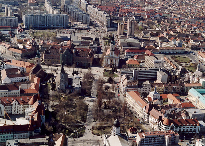
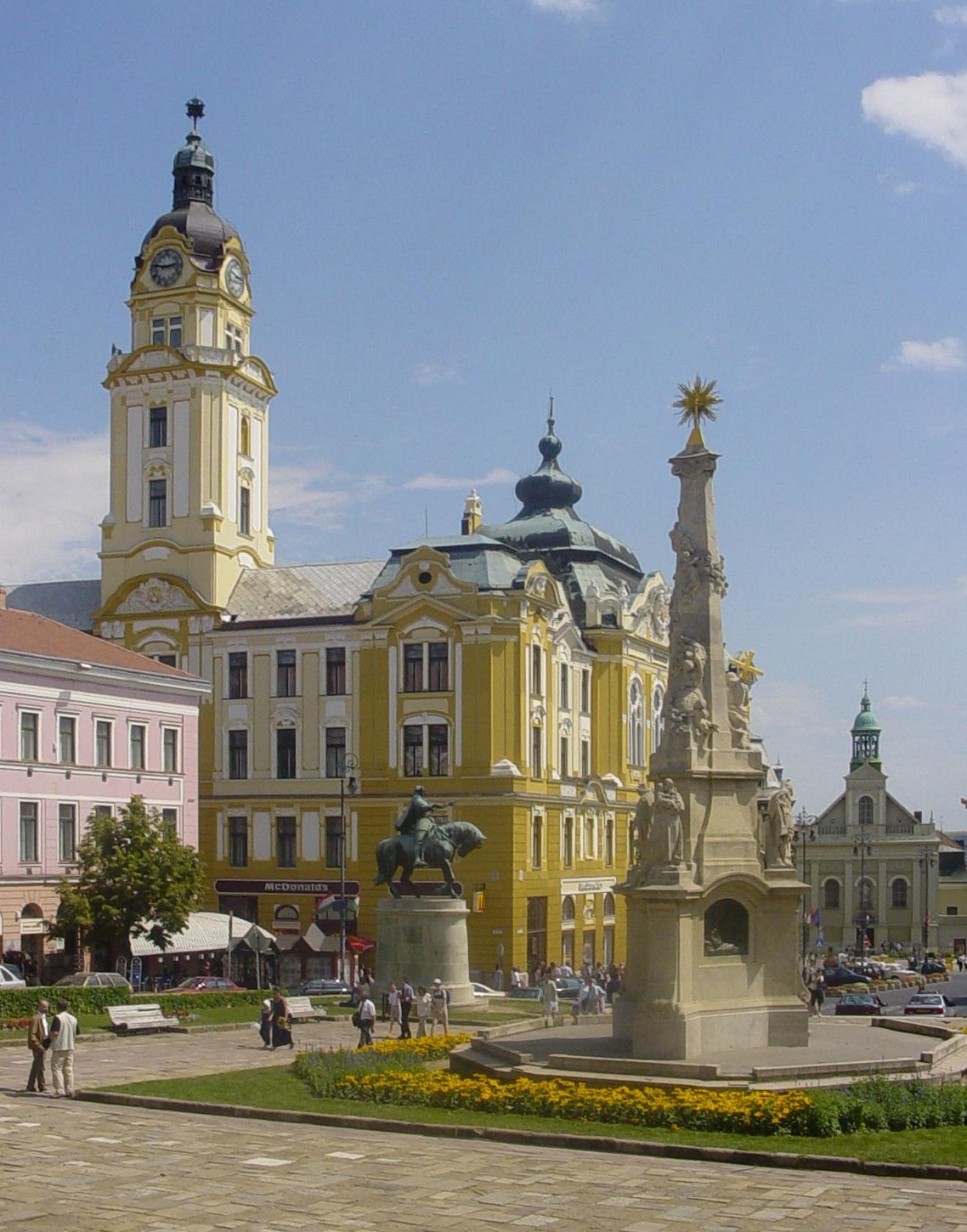
Pécs es una de las cinco ciudades más grandes de Hungría, y está situada al suroeste del país, a 200 km de la capital Budapest.
Széchenyi-Square
Tiene una población de 160.000 habitantes. Pécs es el centro administrativo y económico del condado de Baranya.
La principal ciudad de esta región, fue colonizada por los romanos, en tiempos del Imperio Romano recibió el nombre de Sopianae.
Alberga la quinta universidad más antigua de Europa (1367), la Universidad de Pécs, anteriormente conocida como Universidad Janus Pannonius por el talentoso poeta de origen croata (Janus Pannonius Vitesius; Ivan Česmički, en lengua vernácula; 1434-1472) que fuera nombrado obispo de Cincoiglesias (Pécs) por el papa Pío II (Eneas Silvio Piccolomini) en 1460 y que actuara como emisario del rey Matías Corvino de Hungría.
The Barbakán.
Pécs tiene los mejores ejemplos en Hungría de arte otomano, construidos durante la ocupación turca (1543-1686).
Entre los lugares de interés turístico destacan la Catedral, la Mezquita de Gazi Kasim Pasha y el Museo Arqueológico.
Economy
Located in the midst of an agricultural area, Pécs is the natural hub of local products. Until some years ago, it had a coal mine and even a Uranium mine. Several factories exist, but since the fall of the Iron Curtain those have mostly not managed the transition. It does have a quite famous porcelain factory. The Zsolnay Porcelain has a special greenish colour — called "eozin". One of the walls of a local McDonald'sPécsi Sörfőzde (Pécs Brewery) is one of the four main Hungarian breweries, and produces a special beer, which is not strained before bottling, and can only be bought in a single restaurant in the entire country, the Cellárium. This brew is highly sought after.
Transport
--There are several daily trains connecting Pécs to the capital Budapest as well as a daily direct train to Vienna and direct train to Osijek and Sarajevo.
--A new highway is currently under construction, connecting Pécs and Budapest that will significantly reduce the driving time between the two cities taking about 3 1/2 hours now
--A new airport opened in Pécs (Pécs-Pogány Airport) in March 2006.


 .
.


 .
.


 .
.


 .
.


 .
.


Comentario